ACCESS
Highway A4 (Torino-Milano), take direction for Gravellone Toce A26, exit Romagnano Sesia, continue for Serravalle Sesia, Borgosesia, Alagna Valesesia, parking
ITINERARY
From Alagna take the cable car up to Pianalunga and then with the chairlift up to the Bocchetta delle Pisse past the snack bar and follow the path that leads to the base of the rocky ridge where it begins the via ferrata. It 's also possible to climb the route 5 from the hamlet Piane to Bocchetta delle Pisse (h 3.30).
There are three routes shown on the sign of the ferrata:
GREEN easy path (F)
BLUE It is a well-equipped ridge path (PD for development and height) in the second part of the ferrata.
RED It is the first part of the ferrata (D). Note that the "red" route can be avoided by using the green route and start the blue route.
· GREEN PATH
there are no difficulties, you do not need equipment. the green route allows you to bypass the red path in its initial part, Tibetan bridge and ledge, but you can only avoid the initial part and continue starting from the Tibetan bridge and ledge, from that point there are no escape routes.
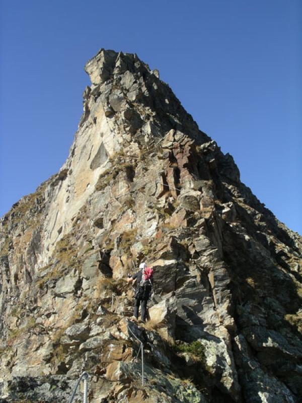
· RED PATH first part
The first part is the most athletic, the path begins with a short vertical stretch. The start of the ferrata is very selective as you climb on rock. Go down a few meters and cross a ravine along a rope bridge, be careful because the cables are not very taut and you can swing in the middle if the wind blows in the channel. Leaving the bridge to cross to the left you will come to a small ledge behind the key point. It grows to about 20 meters vertically, and when you start with a light stretch and a portion overhanging, requires a lot of strength to overcome it. After this section you reach a grassy area where you can rest, you cross grassy ledges and small vertical plates and you get to the top of the ridge and joins the GREEN path and the beginning of the BLUE path.
· BLUE PATH second part
The path continues on the ridge between grassy ledges and vertical plates. The last stretch we pass on a horizontal metal ladder, go up on the plates and you reach a meadow with cairn, indicating the top of mt. 2,800 The ferrata ends, so continue on the ridge and arrive (trail) at the Lodge City of Vigevano mt. 2871, after a short distance you will reach the Rifugio Guglielmina Col d'Olen mt. 2881 and subsequently to the Passo dei Salati mt. 2,936.
DESCENT: