- Lenght
- 15.88 km
- Tempo
- 5 hours 45 minutes
- Tappa
- Max altitude
- 1530 m
- Ascent elevation gain
- 1300 m
- Descent elevation loss
- 250 m
- Difficulty
- Hiking
- Itinerary index
- No
Informazioni
Punto di partenza
RIF. ESC. LA VIA DEL SALE
Via Segheria 2
12030 Sanfront CN
Italy
Punto di arrivo
RIF. ESC. PIAN MUNE'
Loc.tà Pian Muné
12034 Paesana CN
Italy
Come arrivare
Autostrada A6 TORINO - SAVONA, uscita: casello di Marene; svoltare a sinistra ed immettersi sulla S.S. 662 in direzione Savigliano, proseguire fino a Saluzzo, seguire quindi le indicazioni da Saluzzo per la Valle Po lungo la S.P. 26 o la S. P. 260;
autostrada A21 TORINO – ALESSANDRIA – PIACENZA, uscita Asti est – proseguire poi per Alba- Bra- uscita Marene- Savigliano- Saluzzo- Valle Po (S.S. 662);
da TORINO, Tangenziale, uscita Pinerolo, proseguire sulla S.P. 161 poi S.P .27 per Barge, Paesana.
Da Torino e Cuneo: Atibus, orari sul sito www.buscompany.it/Ati, linee Torino-Saluzzo, Cuneo-Saluzzo, Saluzzo-Paesana.
Da Torino e Pinerolo: Autolinee Cavourese, orari sul sito www.cavourese.it, linee Torino – Pinerolo e Pinerolo - Barge.
Da Barge e Paesana: Dossetto Bus, orari sul sito www.dossettobus.it, linea Barge - Paesana - Crissolo.
Descrizione
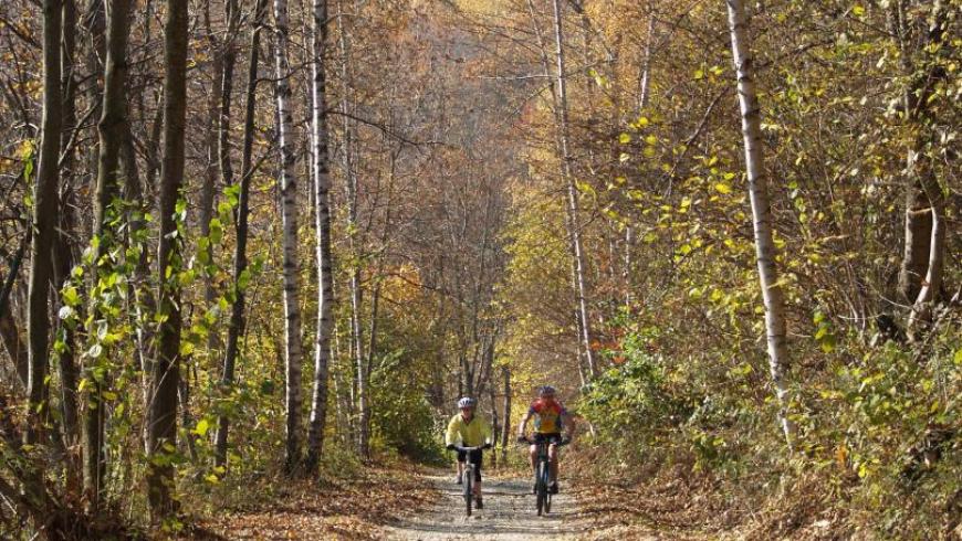
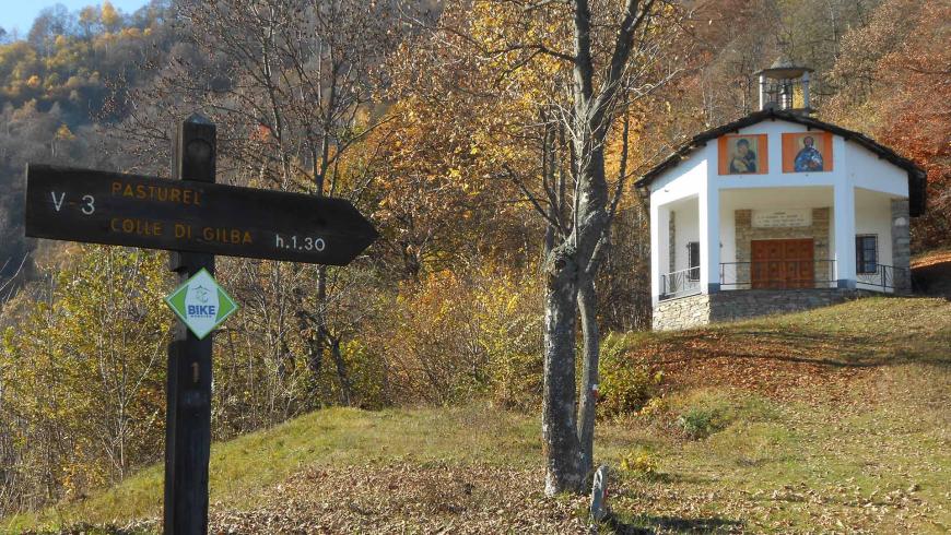
From the mountain hut La Via del Sale, go through the whole village; the road, constantly uphill, crosses the Albetta stream and climbs up the homonymous combe up to a fork at a hairpin bend. Take the dirt road on the left that goes up into the wood with a good slope and reaches the chapel of San Bernardo (1075m - equipped area). A softer path, first in the woods and then in the open field, then again in the woods, leads to the Colle di Gilba esplanade (1524m - equipped area), connecting point with the Varaita Valley. The descent begins just before the col and bends in the direction of the Po valley along a direct path that is first grassy and then technical; a long slight slope to the left in the pine forest, some streams, then a trail lead first to the Forest Hut Bertorello (1375m), then uphill to Pian Muné where the mountain hut is located.
Recommended period
Accessible to people with disabilities
Support points
Rifugio Escursionistico La Via Del Sale (Sanfront)
Rifugio Bertorello, Rifugio Escursionistico Pian Muné (Paesana)
Interest points
Cappella di San Bernardo
Colle di Gilba, punto panoramico e nodo intervallivo
Dettagli
Profilo altimetrico
Dati tecnici
- Code
- OMV
- Classification
- Provincial - Mid and Low Altitude
- Local Tourist Agency (LTA) reference
- ATL del Cuneese - valli alpine e città d'arte
- Cell phone coverage
Copertura buona nei centri abitati di Sanfront e Paesana e lungo gran parte del percorso; possibile minor copertura in alcuni tratti dell'itinerario.
- Country
- Italy
- Region
- Piemonte
- Province
- Cuneo
- Devotional relevance
- Sì
- Historical relevance
- Yes
- Ultima data di aggiornamento
- 15/12/2023
Altre info
Accommodation facilities
Related apps

Trekviso
Escursionismo Piemonte: Terre del Monviso Itinerari escursionistici nelle valli del Cuneese: Po, Bronda, Varaita, Maira
Tappe
Tappe attività
-
0Orizzonte MonvisoLunghezza74.89 kmTempo1 day 2 hours 35 minutesDifficoltàHiking
-
1Stage 1: rif. esc. la via del sale - rif. esc. pian munèLunghezza15.88 kmTempo5 hours 45 minutesDifficoltàHiking
-
2Orizzonte Monviso - Tappa 2: Rif. esc. Pian Muné - Rif. esc. LossaLunghezza13.08 kmTempo3 hours 45 minutesDifficoltàHiking
-
2AStage 1a: paesana - bivio quota 1435Lunghezza8.84 kmTempo4 hours 10 minutesDifficoltàHiking
-
2BOrizzonte Monviso - Tappa 2A: Rif. Esc. Pian Muné - bivio Croce Tournour (Paesana)Lunghezza8.34 kmTempo3 hoursDifficoltàHiking
-
3Stage 3: rif. esc. lossa - crissoloLunghezza9.86 kmTempo3 hours 50 minutesDifficoltàHiking
-
4Stage 4: crissolo - rif. esc. la galabernaLunghezza5.90 kmTempo2 hours 15 minutesDifficoltàHiking
-
4AOrizzonte Monviso - Stage 4A: Crissolo - Borgo hamletLunghezza2.52 kmTempo1 hourDifficoltàHiking
-
5Stage 5: rif. esc. la galaberna - bg.ta ferrereLunghezza8.50 kmTempo3 hours 30 minutesDifficoltàHiking
-
6OMV Tappa 6: Borgata Ferrere - Località CollettaLunghezza9.81 kmTempo3 hours 20 minutesDifficoltàHiking
-
7Orizzonte Monviso - Tappa 7 Loc. Colletta - Rif. esc. La va del saleLunghezza11.86 kmTempo4 hours 10 minutesDifficoltàHiking